About TWA GBBP
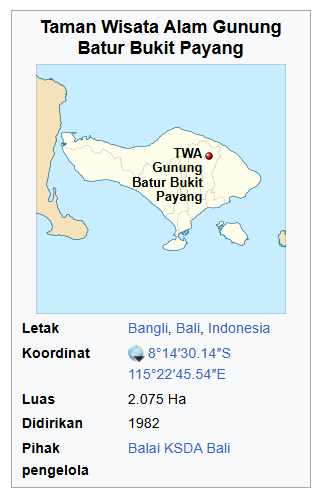
Taman Wisata Alam Gunung Batur Bukit Payang
Taman Wisata Alam (TWA – GBBP) Gunung Batur Bukit Payang, is a protected nature reserve under Indonesian Conservation laws since 1982. The law defines “Taman Wisata Alam” as a nature conservation area that is used for academic, recreation and tourism activities, with strict regulations enacted to preserve its conservation value and biodiversity.
TWA GBBP spans 2.075 hectares within the Batur Caldera, which is recognised as part of UNESCO Global Geopark Network.
Conservation Value
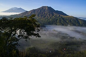
The TWA (Taman Wisata Alam) Gunung Batur Bukit Payang area is primarily known for its captivating mountain ecosystem landscapes, characterized by the geological formations of volcanic rock from the ancient eruptions of Mount Batur (a geosite). It is also part of the Batur UNESCO Global Geopark.
Mount Batur itself is notable for its volcanic activity, as it remains one of the active volcanoes on the island of Bali. For nature enthusiasts, Mount Batur is a popular destination for hiking activities. Additionally, the area is home to natural hot springs, further enhancing its appeal to visitors.
History
The forest complex of Gunung Batur Bukit Payang was designated as a forest area through a decree issued by the Governor-General of the Dutch East Indies, as outlined in Staatsblad Number 28 Sub A.a.4, dated May 29, 1927.
- On August 9, 1933, boundary adjustments were carried out in accordance with the Grensregeling Process Verbaal (Boundary Regulation Minutes), which were formally ratified on March 19, 1934.
According to the Decree of the Minister of Agriculture Number 821/Kpts/Um/11/1982, dated November 10, 1982, regarding the designation of forest areas in the Province of Bali, covering an area of 125,513.8 hectares, and later reinforced by the Decree of the Minister of Forestry and Plantations Number 433/Kpts-II/1999, dated July 15, 1999, regarding the designation of forest areas in the Province of Bali covering 130,686.01 hectares, the Gunung Batur-Bukit Payang Forest Group (RTK.7) was officially designated as a Limited Production Forest and a Nature Tourism Park (Taman Wisata Alam).
Based on the boundary function arrangements recorded in the Examination Report (Berita Acara Pemeriksaan or BAP) titled “Boundary Function of the Gunung Batur-Bukit Payang Forest Area (RTK.7)”, conducted in Bangli Regency, Bali Province, on March 31, 1994, it is documented that the Gunung Batur-Bukit Payang Forest Area (RTK.7) is divided into two functional zones: a Nature Tourism Park (Taman Wisata Alam) covering an area of 2,075 hectares and a Limited Production Forest spanning 453 hectares.
The Decree of the Minister of Forestry Number 355/Kpts-II/1987, dated November 7, 1987, stipulates that the Limited Production Forest within the Gunung Batur-Bukit Payang Forest Area (RTK.7), covering 453 hectares in Bangli Regency, Bali Province, should be merged with the Nature Tourism Park area of 2,075 hectares. This integration creates a unified management entity within the Gunung Batur-Bukit Payang Forest Area (RTK.7).
Finally, the Decree of the Minister of Forestry Number SK.204/Menhut/II/2014, dated March 3, 2014, officially designated the Gunung Batur-Bukit Payang Forest Area (RTK.7) with a total area of 2,528 hectares. This includes 2,075 hectares allocated as a Nature Tourism Park and 453 hectares designated as Limited Production Forest. The area is situated within Bangli Regency, Bali Province.
Location and Borders
TWA GBBP, or The Gunung Batur-Bukit Payang Nature Tourism Park (TWA) is geographically positioned between 8º13’30.92” to 8º16’41.91” South Latitude and 115º20’30.31” to 115º24’2.09” East Longitude.
Administratively, the TWA area is located in Kintamani Subdistrict, Bangli Regency, Bali Province. Its boundaries are as follows:
- •North: Adjacent to Mount Batur and surrounding areas.
- •East: Bordered by the village regions of Songan and Batur.
- •South: Overlooking Lake Batur and its lakeshore settlements.
- •West: Framed by the slopes of Bukit Payang and its natural forested areas.
This strategic location provides a harmonious balance between accessibility and preservation, making it a vital ecological and cultural asset.
Topography
Kawasan TWA Gunung Batur Bukit Payang berada pada ketinggian lk. 1.044 – 1.717 m dpl. (puncak G. Batur) dengan kelerengan landai sampai dengan sangat curam.
Topography and Geology of TWA GBBP
The Gunung Batur-Bukit Payang Nature Tourism Park (TWA) is situated at an elevation of 1,044 to 1,717 meters above sea level, with terrain ranging from gentle slopes to steep inclines, culminating at the peak of Mount Batur.
The soil in this region is classified as Grey Regosol, formed from volcanic ash deposits. This type of soil is coarse-grained, grey to yellowish in color, and low in organic content. As a result, it doesn’t retain water or nutrients well, making it less suitable for most crops. However, it supports hardy plants like tobacco, fruits, and certain vegetables that require less water. These soils are typically found on the slopes of volcanic mountains.
From a geological perspective, the Batur Caldera features volcanic rock formations, including agglomerates, lava, and tuff, making it a fascinating site for geologists and nature enthusiasts alike.
In terms of landslide vulnerability, the area falls into low, medium, and high-risk zones, as identified in Bali’s Landslide Susceptibility Map. This diversity of risk underscores the dynamic and ever-changing nature of the landscape, shaped by its volcanic origins.
Watershed and Management System of TWA GBBP
The Gunung Batur-Bukit Payang Nature Tourism Park (TWA) is part of the Blingkang Anyar Watershed System (DAS), with its upstream source originating from Mount Batur. This vital watershed plays a key role in sustaining the region’s hydrological balance.
In terms of administrative management, the park falls under the jurisdiction of the Gunung Batur-Bukit Payang Resort, which is part of the Kintamani Forest Protection Management Unit (KPHK). This unit operates under Conservation Section II of the Bali Nature Conservation Agency (Balai KSDA Bali), ensuring proper conservation and sustainable use of the area’s natural resources.
Climate & Meteorology at TWA GBBP
Climate & Meteorology of TWA GBBP
According to data from the Meteorology, Climatology, and Geophysics Agency (BMKG), Region III Denpasar, the Kintamani District falls into three climate classifications based on the Schmidt and Ferguson system: B (Wet), C (Moderately Wet), and D (Medium).
The area experiences an average annual rainfall of 1,489 mm, with humidity levels ranging from 75% to 90%. Temperatures typically range between 20°C to 30°C throughout the year, creating a relatively cool and comfortable climate compared to the rest of Bali.
Flora & Fauna
Flora of TWA Gunung Batur Bukit Payang
The forest within the area is primarily composed of planted species rather than native ones. Dominant species include ampupu (Eucalyptus urophylla), pine (Pinus merkusii), and sonokeling (Dalbergia latifolia). However, native species such as cemara gunung (Casuarina junghuhniana) and seming (Pometia sp.) can still be found.
In addition to trees, the area is home to various shrubs, bushes, and herbaceous plants, including species like kacing landa, kerasi (Lantana camara), forest papaya, ketiblun, kayu sinduk, kayu padi, kayu tulak (Schefflera sp.), padang bagas, kasua, kesimbukan, ferns, and gelagah grass. This diverse plant life enriches the ecosystem, supporting a variety of habitats.
Fauna of TWA Gunung Batur Bukit Payang
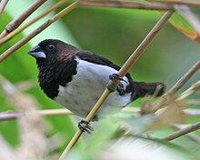
The area is home to a diverse array of bird species, making it a significant spot for birdwatching and ecological study. Among the recorded species are:
- •Small Birds: Bondol Jawa (Lonchura leucogastroides), Bondol Peking (Lonchura punctulata), Burung Gereja (Passer montanus), Gelatik Batu (Parus major), and Cipoh Kacat (Aegithina tiphia).
- •Predatory Birds: Alap-alap (Falco moluccensis), Elang Bido (Spilornis cheela), and Elang Brontok (Nisaetus cirrhatus).
- •Forest Birds: Ayam Hutan Merah (Gallus gallus), Takur (Megalaima sp.), and Cerukcuk (Pycnonotus goiavier).
- •Nocturnal Birds: Beluk Ketupa (Ketupa ketupu) and Cabak Kota (Caprimulgus affinis).
- •Water-associated Birds: Cekakak Sungai (Todiramphus chloris).
- •Insectivorous Birds: Decu Belang (Saxicola caprata), Sikatan Bodoh (Ficedula westermanni), and Meninting Besar (Enicurus leschenaulti).
- •Other Notable Species: Perenjak Jawa (Prinia familiaris), Madu Sriganti (Nectarinia jugularis), Kacamata Biasa (Zosterops palpebrosus), and Punai Gading (Treron vernans).
This diverse bird population not only enriches the ecosystem but also offers opportunities for ecotourism and scientific research. The combination of small birds, predatory species, and unique forest dwellers underscores the ecological richness of TWA Gunung Batur Bukit Payang.